




Monday, 28 September 2026 07:00 AM
Company Update
VANCOUVER, BC / ACCESS Newswire / September 28, 2026 / Irving Resources Inc. (CSE:IRV)(OTCQX:IRVRF)(FSE:1IR) ("Irving" or the "Company") is pleased to announce completion of detailed geological, geochemical and geophysical surveys around the historical Unoya Mine within its Shika epithermal gold-silver project, Noto Peninsula, Honshu, Japan (Figure 1).
Highlights:
- Mapping confirms that silicification and argillic alteration resulting from hydrothermal activity has affected the Early to Middle Miocene Besshodake Andesite and associated pyroclastic rocks and lacustrine sediments throughout the historical Unoya Mine area.
- Gold-bearing quartz vein float occurs both around the historical Unoya Mine workings as well as within a separate, recently identified area approximately 1 km further south. Irving geologists believe these are part of en echelon veining system that is related to a potential shear structure underlying the region.
- Sample NT0674, a float vein sample collected from the southern area, contains dark silver-rich bands ("ginguro") and returned the highest assay values of 62.3 g/t Au and 604 g/t Ag.
- Irving's drone magnetic survey has identified a zone of subdued and relatively uniform magnetic response measuring approximately 2.5 km by 1.0 km. Distribution of gold-bearing quartz vein float and altered rocks corresponds closely with this depressed magnetic feature. Therefore, Irving's geologists believe that hydrothermal alteration has resulted in the destruction of magnetite within volcanic rocks resulting in this magnetic flat.
About Irving's Noto Epithermal Au-Ag Projects:
The Company's 99 Noto prospecting licenses and license applications (337.37 sq km) cover four discrete target areas displaying stream sediment gold, silver, arsenic, antimony, mercury and/or copper anomalism. Once all have been granted, these would make Irving the largest holder of prospecting licenses in the Noto area (please refer to the Company's news release dated March 18, 2026). The Noto Project is a joint venture between Newmont Overseas Exploration Limited ("Newmont"), a wholly owned subsidiary of Newmont Corporation, Sumitomo Corporation ("Sumitomo") and Irving (the "JV"). The initial and current interests of the parties in the joint venture are Newmont, 60%, Sumitomo, 12.5%, and Irving, 27.5%.
The Company's previous reconnaissance program in the Unoya area, as reported in its news release dated March 18, 2026, identified gold-bearing quartz vein float extending approximately 1.2 km northeast and southwest of the historical Unoya Mine. Assays from these samples returned values of up to 38.5 g/t Au and 45.6 g/t Ag. High-grade vein material was particularly abundant in the southeastern part of the area. Higher-grade vein float consists of chalcedonic to very fine-grained quartz, commonly displaying delicate crustiform banding.
To better understand the overall mineralized system, the Company conducted follow-up geological mapping, rock sampling, grid-based soil geochemical sampling and a high-resolution drone-borne magnetic survey in May and June 2026.
Noto Peninsula shares geological characteristics with nearby Sado Island, which hosts the historical Sado Kinzan gold mine (Mitsubishi Materials Corporation). Sado Kinzan Mine operated for 388 years beginning in 1601, when it came under the direct control of the Tokugawa Shogunate. It boasts total recorded production of approximately 2.51 million ounces of gold and 74 million ounces of silver (The Mining and Materials Processing Institute of Japan, 1994, Nihon Kinzanshi 4: Kanto and Chubu). No assurance can be given that Irving will achieve similar results at its Noto Project.
Based upon the encouraging results discussed in this news release, the JV is considering drilling as the next phase of exploration in the Unoya area. Irving's Noto Project is the Company's third Japanese exploration project, the other two being the Omu Project, Hokkaido, which has advanced to the resource development stage, and the Yamagano Project, Kyushu, where scout drilling is currently underway. Combined, these three projects comprise the Company's pipeline of projects spanning early-stage exploration through development.
Detailed Results: Unoya area, Shika Prospect:
Figure 1 shows the location of the Unoya area within the broader block of Shika prospecting licenses. Shika prospect was staked based upon the elevated gold values obtained from bulk leach extractable gold ("BLEG") stream-sediment surveys. Figure 2 displays rock and soil sampling locations from surveys conducted in October 2025 and May-June 2026 as well as the area of the May 2026 drone-borne magnetic survey.
Geological Survey
Geological mapping was conducted by Irving's field team for the period from May 8 to 20, 2026 across an area characterized by dense vegetation and a humid monsoonal climate (Figure 3a).
Local topography is dominated by the prominent, linear Togi River valley trending north-northeast to south-southwest. This valley forms a narrow, flat-lying area that is largely used for rice cultivation. Elevation along the valley ranges from approximately 80 to 100 metres above sea level. The terrain east of the Togi river is hilly to mountainous and includes two prominent peaks, Mt. Kazafukidake (354 m above sea level), and Mt. Kawachidake (399 m above sea level). These peaks are elongated broadly parallel to the Togi river. West of the river, the terrain is more subdued with elevations less than 300 metres. Here, the north-northeast to south-southwest structural trend is less evident.
Figure 3b presents the geology of the Unoya area. The historical Unoya Mine is located east of the Togi river, near a central point where several catchments displaying anomalous BLEG gold values converge (Figure 2). Detailed historical information concerning the historical Unoya Mine, including past production records, has yet to be identified by the Irving team. The Unoya area is predominantly underlain by the Early to Middle Miocene Besshodake Andesites, consisting mainly of hornblende-bearing pyroxene andesite, with subordinate volcaniclastic and pyroclastic rocks. A K-Ar age of 15.9 Ma has been reported for andesite collected in the vicinity (Shibata et al., 1981, J. Japan. Assoc. Mineral. Petrol. Econ. Geol.). Three or four horizons of silty lacustrine sedimentary rocks are intercalated within the Besshodake Andesites succession. Based on observed bedding orientations, the volcanic and sedimentary succession appears to dip gently southward.
All lithologies within the Besshodake Andesites succession host gold-bearing quartz veins and suffer varying degrees of hydrothermal alteration and brecciation, including zones of intense silicification and mineralization (Figure 4). One historic working identified during Irving's survey was excavated within a strongly silicified silty horizon (Figure 4a). This siltstone horizon is less than ten metres thick, and host rocks rapidly change upward into silicified andesite and pyroclastic rocks (Figure 4b).
Relatively unaltered glassy andesite occurs at the northeastern end of the survey area. This unit is provisionally referred to as "Upper Andesite." It is not yet known whether Upper Andesite represents a post-mineralized volcanic unit. Andesitic to dioritic dykes are also present, particularly in the northern part of the area.
Geochemical Rock Sampling
Spot and float rock sampling was conducted concurrently with geological mapping. Quartz vein and silicified-rock samples were submitted to ALS in Perth for assay. X-ray diffraction analyses were also performed on argillized host-rock samples to identify their constituent clay minerals by Mineral Resource Science Lab., Akita, Japan.
Several quartz vein float samples collected both near and distal to the historic Unoya Gold Mine returned gold values exceeding 4 g/t Au (Table 1; Figures 5). Of the 56 quartz vein and float quartz vein samples collected during the 2026 program, 13 returned values greater than 1 g/t Au. The highest-grade sample, NT-0674, is comprised of quartz vein material returning 62.3 g/t Au and 604 g/t Ag (Table 1, Figure 5a). This vein sample consists predominantly of very fine-grained quartz, locally chalcedonic, with minor pyrite and delicate crustiform banding (Figure 5). Complex cross-cutting relationships indicate multiple stages of vein formation. Only minor amounts of sulfide minerals are associated with veins.
Quartz veins in the Unoya area are interpreted to trend northeast-southwest, based on the distribution of quartz vein float and the configuration of the historical underground workings. Irving's geologists have found no quartz vein outcrops during exploration to date, thus the exact orientation and mode of occurrence of veins remain unknown.
Of 115 variably altered host-rock samples collected from outcrop, two returned values greater than 1 g/t Au. The highest-grade host-rock sample, NT-0793, is comprised of silicified rock and returned 2.1 g/t Au and 11.6 g/t Ag (Figure 4a).
Clay minerals occurring in altered rocks include smectite, smectite/illite mixed-layer, halloysite and kaolinite. Analysis of the alteration-mineral assemblages remains in progress. Hydrothermal alteration zoning documented at the Hishikari Mine, a typical low-sulfidation epithermal vein system in Japan, indicates that smectite/illite mixed-layer occurs at the uppermost part of the gold-mineralized interval (e.g., Ibaraki and Suzuki, 1990, Mining Geology).
Based on the observed vein textures and alteration-mineral assemblages, Irving's geologists interpret the present erosional level in the Unoya area to be relatively high-level. This interpretation suggests that the more prospective part may occur at depth.
Table 1 High-grade vein float samples collected in the historical Unoya mine area. Location is shown in Fig. 3

The results disclosed in this news release are not necessarily representative of mineralization throughout the Unoya area.
Grid Soil Geochemical Survey
Systematic grid-based soil sampling in the Unoya area was carried out by Irving's technical team from June 1-13, 2026 and covered approximately 5.4 sq km (Figure 2). Sampling was conducted along 13 northwest-southeast-oriented lines spaced 200 metres apart, with samples collected at 50-metre intervals. A total of 548 soil samples, including five field duplicates, were collected from 594 planned sampling locations. Some planned samples could not be collected because the locations fell within cultivated fields, residential properties or areas of landslides.
Samples were dispatched to ALS Global in Brisbane for geochemical analysis. Results are pending.
Drone-Borne Magnetic Survey
A high-resolution drone-borne magnetic survey was conducted over the Unoya area for the period from May 24 to 27, 2026 (Figure 2). This survey covered approximately 10 sq km and comprised 41 west-northwest to east-southeast-oriented flight lines spaced 100 metres apart. North-northeast to south-southwest-oriented tie lines were flown at intervals of approximately 850 metres. The survey was conducted by Mitsui Mineral Development Engineering Co., Ltd. using a DJI Matrice 400 multicopter installed with a GEM Systems GSMP-25U optically pumped magnetometer.
A reduced-to-the-pole ("RTP") magnetic image is presented in Figure 6. Most higher-grade gold-bearing vein float occur within an area characterized by RTP magnetic intensity values of approximately 100 to 300 nT in the central part of the Unoya area. This domain measures approximately 2.5 km long by 1 km wide and may be regarded as a relatively magnetically subdued or uniform zone. Such a magnetically subdued zone can be interpreted to result from hydrothermally altered rocks in which primary magnetite has been destroyed. Such magnetite destruction results in hydrothermal alteration that is directly responsible for gold mineralization (e.g., Craig et al., 1998, Resource Geology). Irving therefore considers this depressed magnetic domain to be prospective for defining potential future drilling targets.
Close examination of the distribution of higher-grade gold-bearing vein samples suggests the presence of two principal clusters: a northern cluster near Y: 4,119,000 and a southern cluster near Y: 4,118,000. This distribution may reflect an en echelon vein setting, a structural pattern commonly observed in Japanese epithermal vein deposits.
Another noteworthy feature is a pronounced negative magnetic anomaly centred at approximately X: 660,000 and Y: 4,119,300 in the north-central part of the Unoya area. This magnetic low broadly coincides with a gravity high shown on the regional gravity map published by the Geological Survey of Japan. Such spatial relationship may indicate the presence of a relatively dense subsurface intrusive body or structural block. Further interpretation will be undertaken through the integrated assessment of geological, geochemical, magnetic and gravity data.
Next Steps at Unoya
The Company is awaiting analytical results from its grid soil geochemical survey and is contemplating a potential drilling program in the Unoya area in 2027.
Given the abundance of mineralized vein material and altered outcrop at surface, Irving considers that potential initial drilling targets may occur at relatively shallow depths. The Company is therefore considering a program of comparatively short reconnaissance drill holes, potentially ranging from approximately 300 to 500 metres in length and oriented broadly northwest-southeast across interpreted structures. Final potential drill-hole locations, orientations and depths will be determined following integration of the geological, rock-geochemical, soil-geochemical and geophysical datasets.
Quality Assurance and Quality Control Measures were strictly applied to both rocks and soils with interchanging OreasTM derived blanks and standards inserted at every 20th sample. Soil and rock samples were dispatched to ALS Global Brisbane and ALS Global Perth, respectively, for geochemical analyses.
Quinton Hennigh (Ph.D., P.Geo.) is the qualified person pursuant to National Instrument 43-101 Standards of Disclosure for Mineral Projects responsible for, and having reviewed and approved, the technical information contained in this news release. Dr. Hennigh is a technical advisor and a director of Irving and has verified the data disclosed including sampling, through review of photographs of core prior to and after sawing and sampling, and analytical, through review of standard and blank analyses.
About Irving Resources Inc.:
Irving is a junior exploration company with a focus on gold in Japan. Irving resulted from completion of a plan of arrangement involving Irving, Gold Canyon Resources Inc. and First Mining Finance Corp.
Additional information can be found on the Company's website: www.IRVresources.com.
Akiko Levinson,
President, CEO & Director
For further information, please contact:
Tel: (604) 682-3234 Toll free: 1 (888) 242-3234 Fax: (604) 971-0209
[email protected]
Some statements in this news release may contain forward-looking information within the meaning of Canadian securities legislation including, without limitation, statements as to planned exploration activities. Forward-looking statements address future events and conditions and, as such, involve known and unknown risks, uncertainties and other factors which may cause the actual results, performance or achievements to be materially different from any future results, performance or achievements expressed or implied by the statements. Such factors include, without limitation, customary risks of the mineral resource exploration industry, the funding of planned drilling and other exploration activities, as well as the performance of services by third parties.
THE CSE HAS NOT REVIEWED AND DOES NOT ACCEPT RESPONSIBILITY FOR THE ACCURACY OR ADEQUACY OF THIS RELEASE
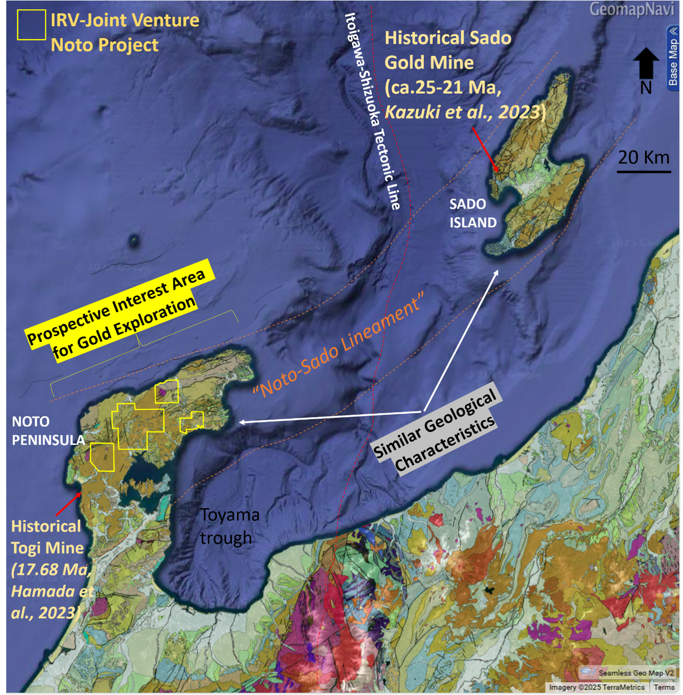
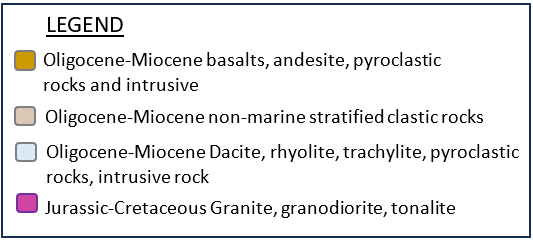
Figure 1
Location of Shika prospect (this work), Irving's prospecting interest area in Noto peninsula, the Sado-Noto region, located along the Sea of Japan coast of central Honshu, superimposed to geological map by Geological Surveys of Japan.
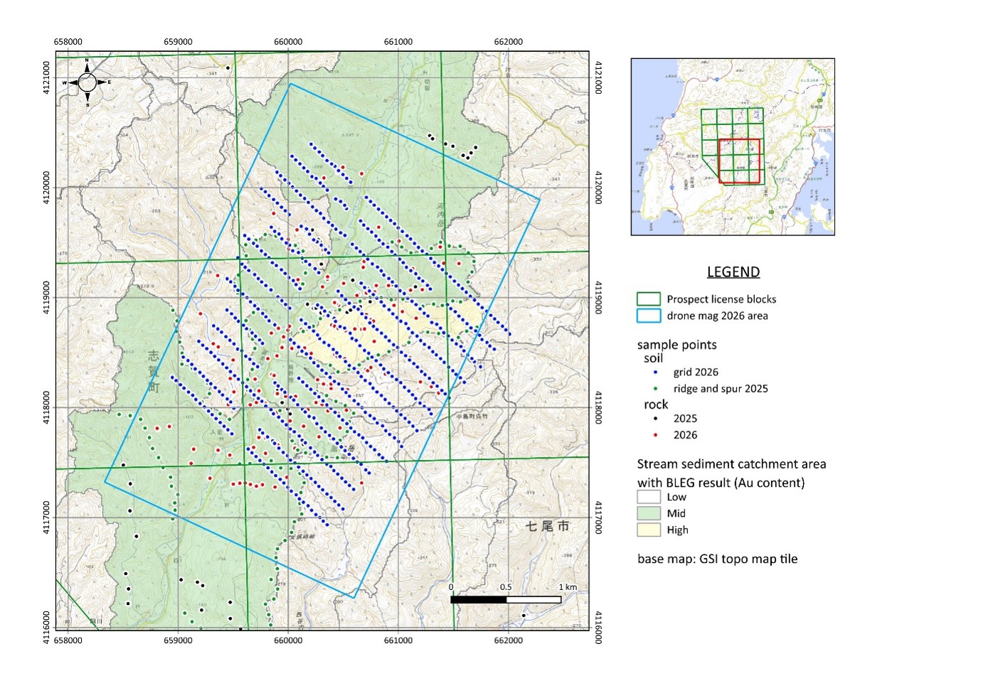
Figure 2
Location of Irving's Exploration Surveys in the Unoya Area, Shika Prospect, Noto Peninsula. Surveys completed in 2026 comprise geological mapping and rock sampling, a grid-based soil geochemical survey, and a drone-borne magnetic survey. Previously reported work comprises reconnaissance and rock sampling and ridge-and-spur soil sampling completed in 2025, as well as a stream-sediment survey using bulk leach extractable gold (BLEG) completed in 2021.
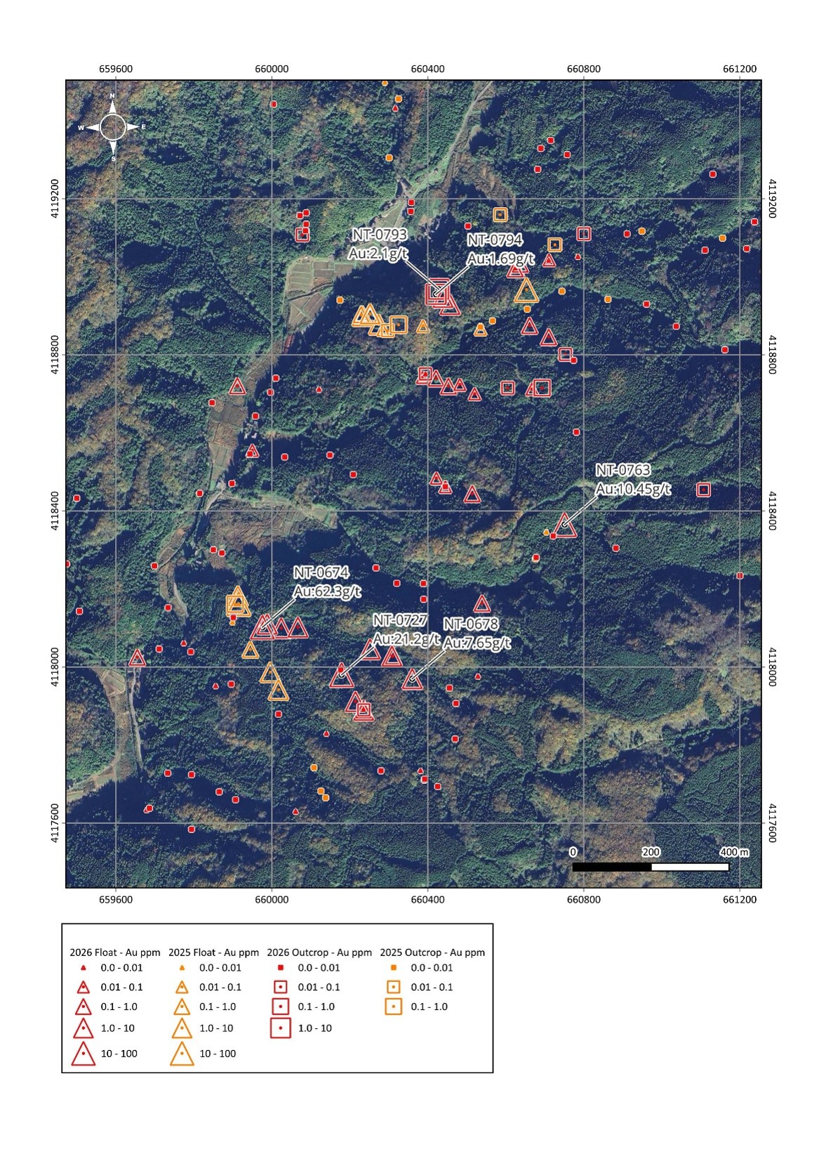
Figure 3a
Satellite image and rock sample locations and part of Au assay results in the Unoya area.
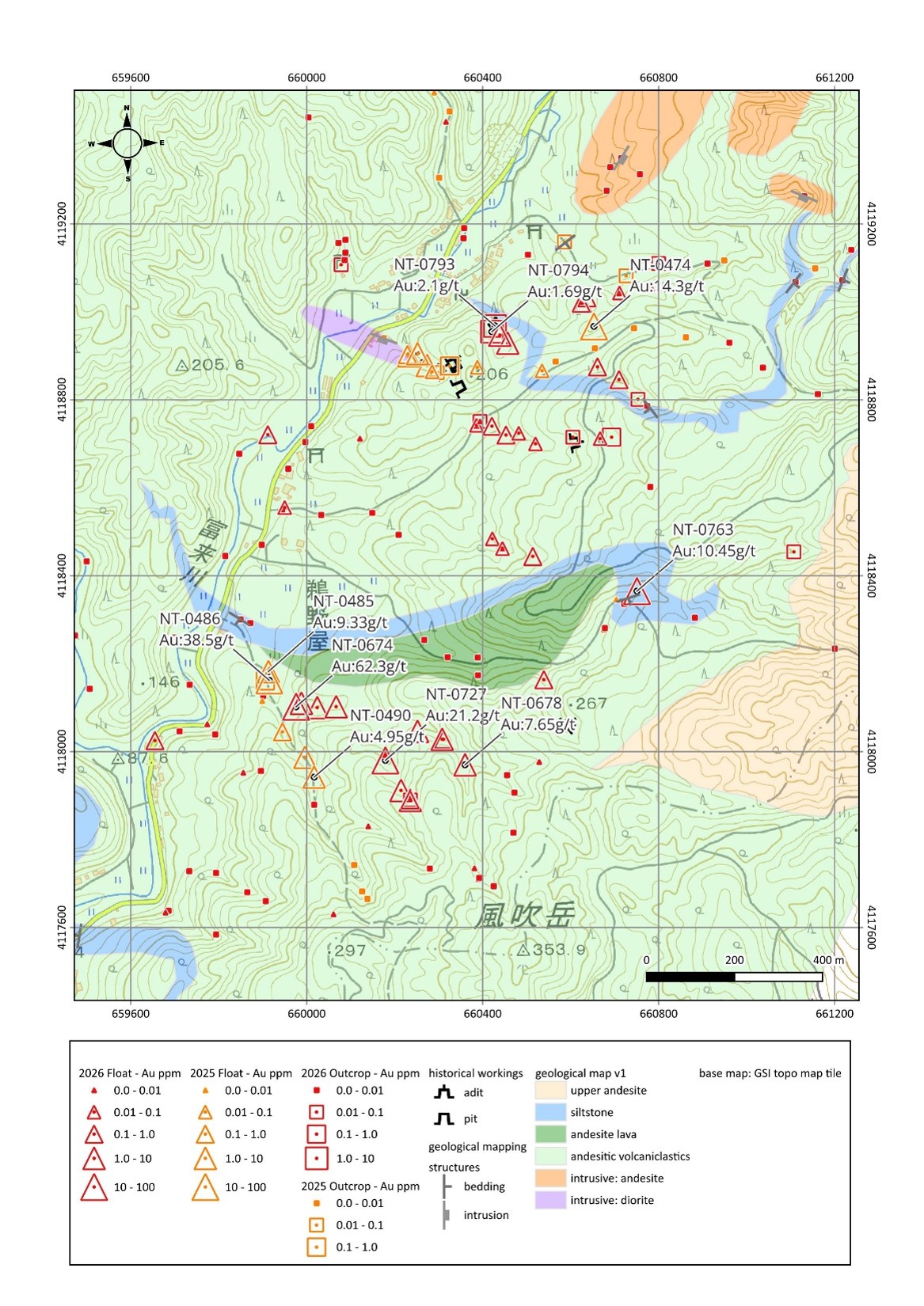
Figure 3b
Geological map and rock sample points and a part of Au assay results in the Unoya area.
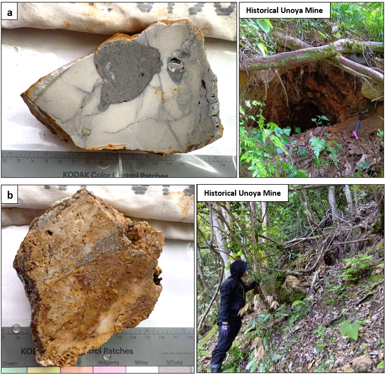
Figure 4
Pictures of silicifies host rock observed around the historical Unoya Mine
a: NT-0793 (2.1 g/t Au & 11.6 g/t Ag) : silicified silt with silicified andesite clast, collected at the historical Unoya Mine pit, which location is shown in Figure 3
b: NT-0794 (1.69 g/t Au & 2.7 g/t Ag) : silicified andesite with dense quartz domain, collected at eight meters above the historical pit of (a)
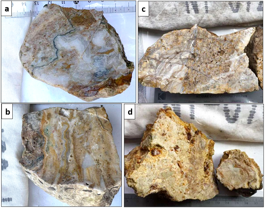
Figure 5
Pictures of sliced vein float samples in the Unoya area. Each sampling location is shown in Figure 3.
a: NT-0674 (62.3 g/t Au & 604 g/t Ag) : quartz Vein with delicate crustiform bandng including dark gray "ginguro" band
b: NT-0678 (7.65 g/t Au & 315 g/t Ag) : : quartz vein with delicate crustiform banding
c: NT-0727 (21.2 g/t Au & 314 g/t Ag) : multiple staged quartz vein with porous silicified andesite clasts
d: NT-0763 (10.5g/t Au & 4.5g/t Ag) : silicified rock with argillized andesitic rock clasts
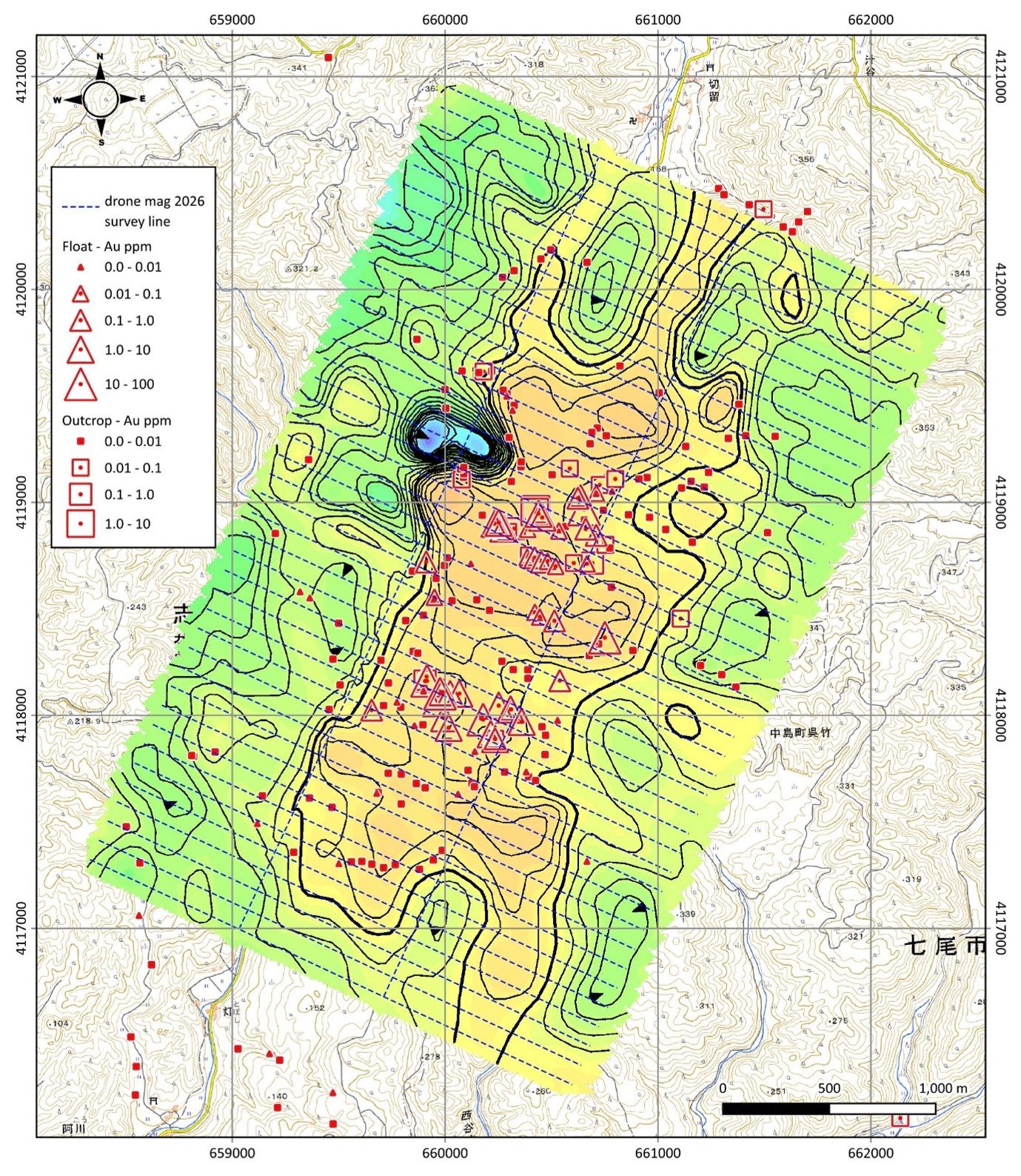
Figure 6
A reduced-to-the-pole ("RTP") magnetic image map in the Unoya area with Au assay results of rock sample in the Unoya area.
SOURCE: Irving Resources Inc.