Pampa Medina Continues to Deliver Extraordinary Cu-Ag Grade-Widths - Drilling Intersects 216m of 1.0% Cu and 7.2g/t Ag Including 62m of 2.2% Cu and 21.5g/t Ag from SPRD-15
Tuesday, 08 September 2026 06:00 AM
Topic:
Company Update
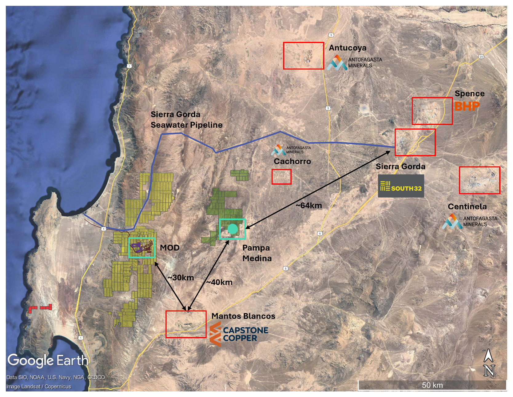
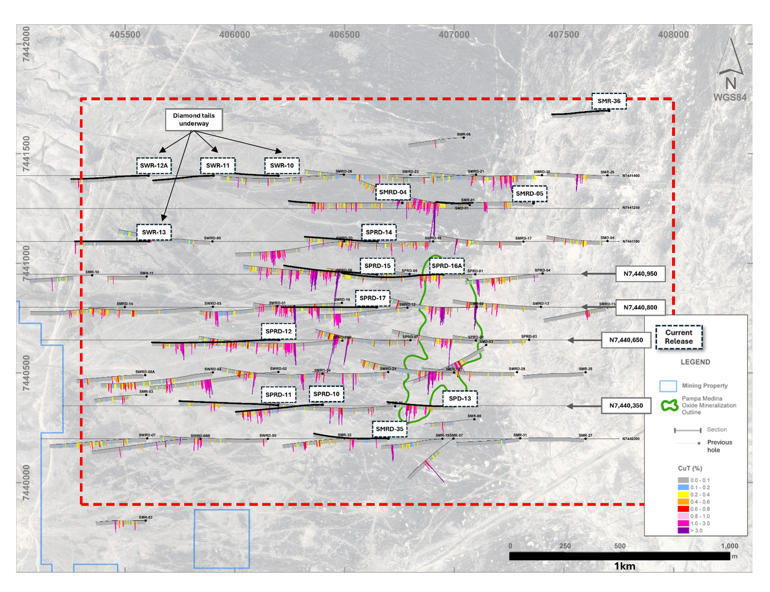
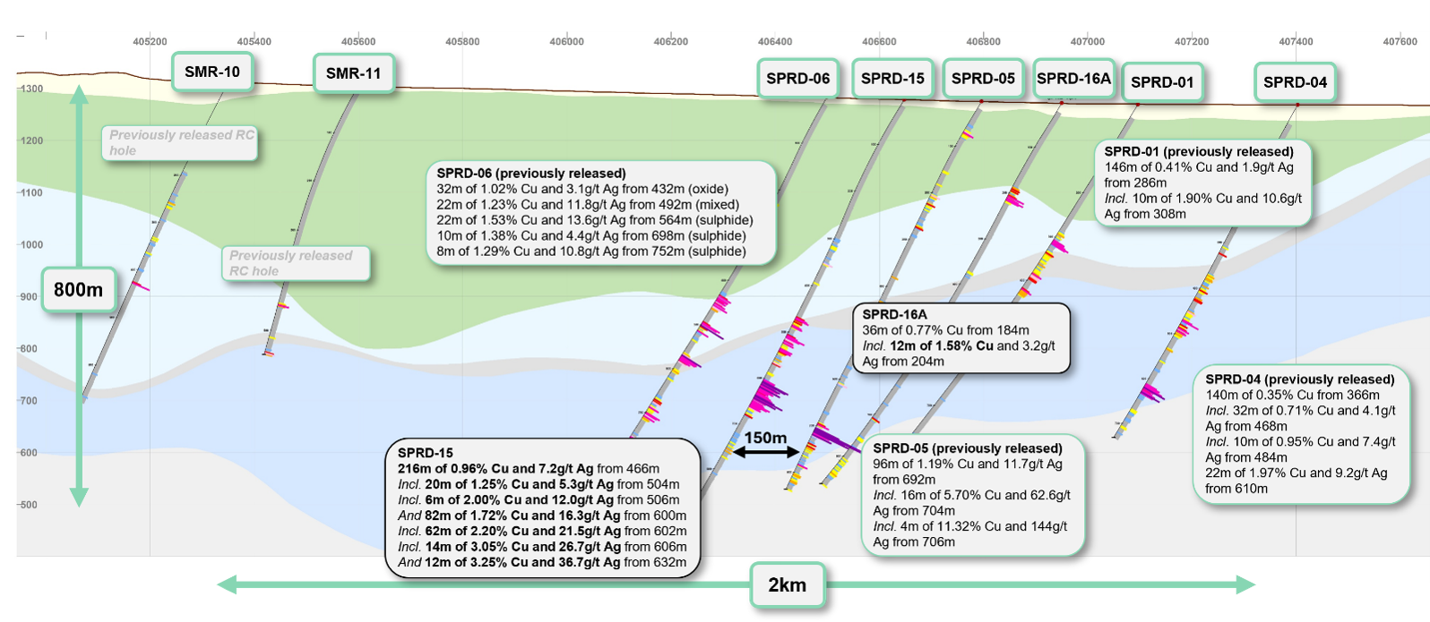
VANCOUVER, BC / ACCESS Newswire / September 8, 2026 / Marimaca Copper Corp. ("Marimaca Copper" or the "Company") (TSX:MARI)(ASX:MC2) is pleased to report further assay results from its ongoing drilling program at the Pampa Medina deposit, located approximately 28km east of the Company's Marimaca Oxide Deposit ("MOD") in Chile's Antofagasta Region (Figure 1). Drilling within the central high-grade sulphide zone continues to deliver consistent, high-grade results within the defined 3km x 1.5km area of interest ("AOI"). The mineralization across the target lithological horizons continues to show continuity both horizontally and vertically. Drilling on 150m centers returned 216m of 0.96% Cu and 7.2g/t Ag from 466m, including 62m of 2.20% Cu and 21.5g/t Ag from 602m downhole from SPRD-15. Step-out drill holes outside of the central corridor extended the mineralized sediment horizon 300m to the south and west, with strong results from SPRD-12, SPD-13 and SPRD-17. Additional scouting RC holes were completed to the north and northwest of the defined AOI to determine the depth of the start of the target sediments (see Figure 3).
Drilling on 150m spacing continues to validate the continuity of the thick, ultra high-grade, stacked-mantos across the core of Pampa Medina
SPRD-15 intersected thick, continuous, high-grade mineralization at the target manto horizon:
216m of 0.96% Cu and 7.2g/t Ag from 466m (sulphide), including
82m of 1.72% Cu and 16.3g/t Ag from 600m, including
62m of 2.20% Cu and 21.5g/t Ag from 602m, including
14m of 3.05% Cu and 26.7g/t Ag from 606m, and
12m of 3.25% Cu and 36.7g/t Ag from 632m
6m of 2.00% Cu and 12.0g/t Ag from 506m
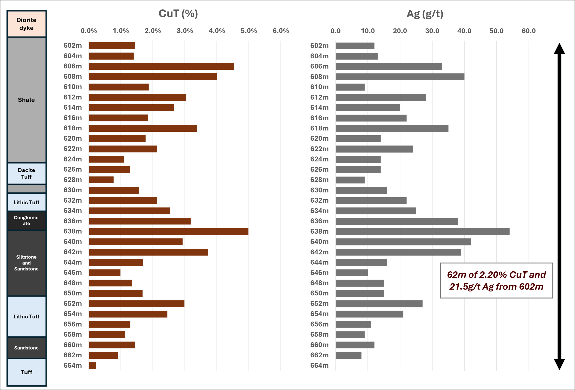
The manto demonstrates remarkable continuity of high-grade mineralization vertically across the horizon (see Figure 4) - a defining feature of the Pampa Medina deposit
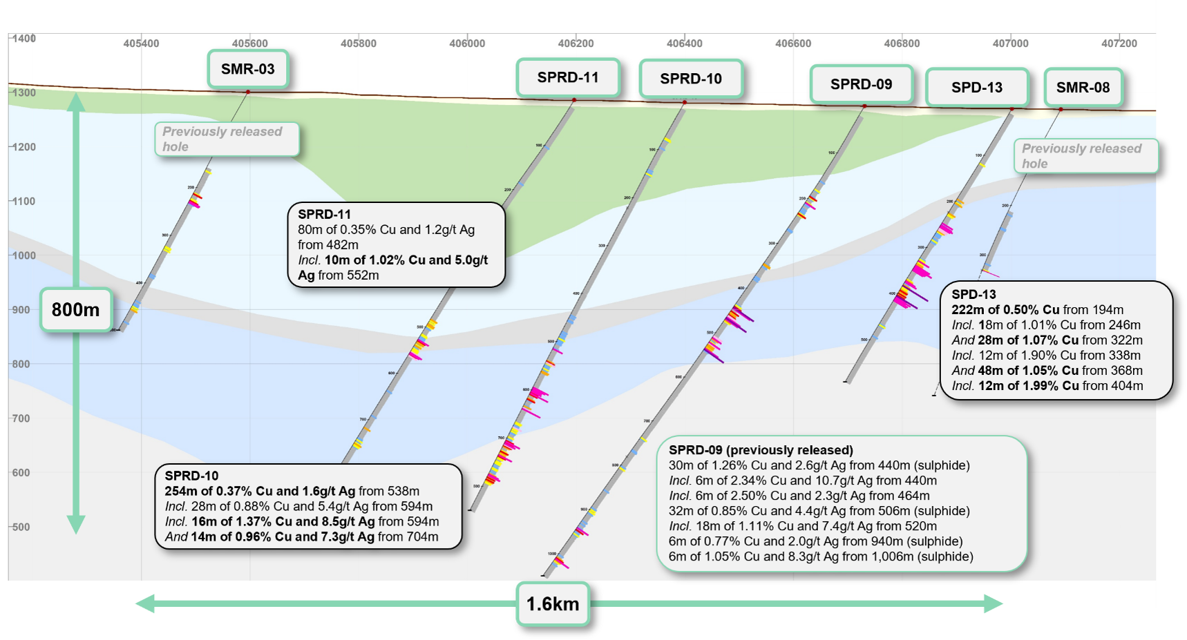
SPD-13 - drilled near the current south-east limit of the historical oxide and new sulphide zones - provided meaningful extensions to both zones (see Figure 3 and 8)
Intersected multiple stacked high-grade mantos at depth across a broad interval of 222m of 0.50% Cu from 194m, including
18m of 1.01% Cu from 246m (oxide)
28m of 1.07% Cu from 322m (mixed), including
12m of 1.90% Cu from 338m
48m of 1.05% Cu from 368m (sulphide), including
12m of 1.99% Cu from 404m
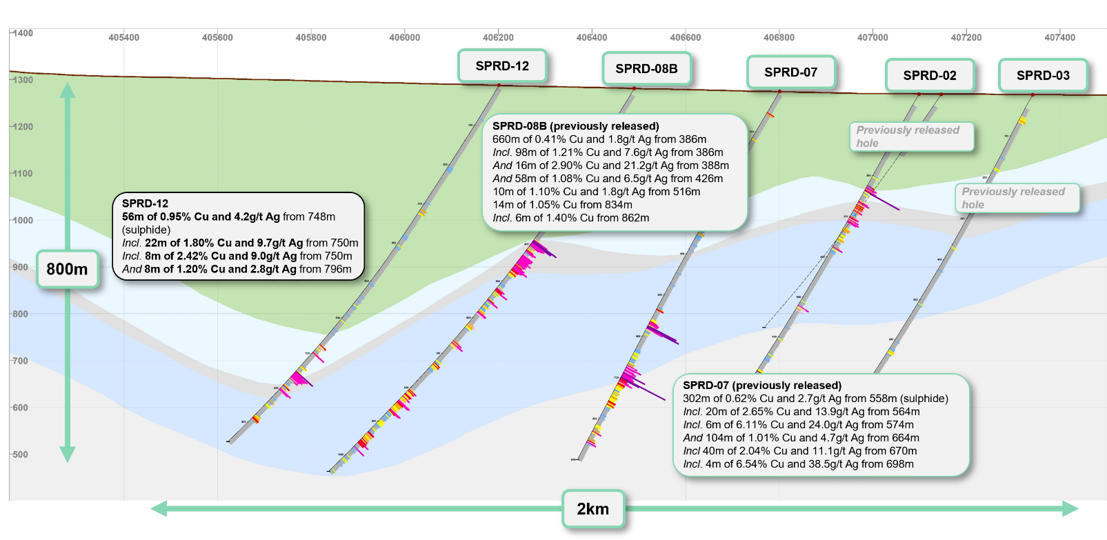
SPRD-12 significantly extended the stacked, high grade, sulphide manto (Figure 3 and 7)
Intersection 300m to the west of previous drilling, with broad zones of high-grade mineralization, including:
56m of 0.95% Cu and 4.2g/t Ag from 748m (sulphide), including
22m of 1.80% Cu and 9.7g/t Ag from 750m, including
8m of 2.42% Cu and 9.0g/t Ag from 750m
8m of 1.20% Cu and 2.8g/t Ag from 796m
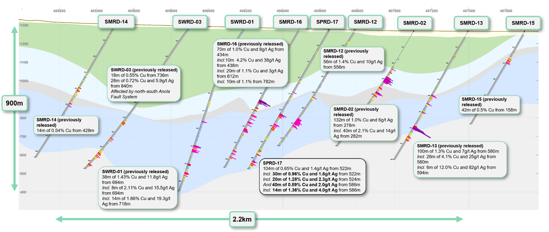
SPRD-17 - drilled 150m east of previously released SMRD-16 (Figure 6) - intersected multiple stacked mantos across 104m of 0.65% Cu from 522m, including
30m of 0.96% Cu from 522m (sulphide), including
20m of 1.28% Cu and 2.3g/t Ag from 524m
40m of 0.89% Cu from 586m (sulphide), including
14m of 1.36% Cu and 4.0g/t Ag from 586m
SPRD-10 drilled on the southern fence, west of SPD-13, intersected
28m of 0.88% Cu and 5.4g/t Ag from 594m (sulphide), including
16m of 1.37% Cu and 8.5g/t Ag (sulphide) from 594m
14m of 0.96% Cu and 7.3g/t Ag from 704m (sulphide)
SPRD-11 - drilled 200m west of SPRD-10 - intersected 10m of 1.02% Cu and 5.0g/t Ag from 552m and was impacted by late dykes
SPRD-14 and SPRD-16A were drilled within the high-grade central zone on 150m centers and intersected post-mineral faulting at depth
SPRD-14 intersected near-surface oxide mineralization: 30m of 0.61% Cu and 4.2g/t Ag from 238m
SPRD-16A also intersected near surface-oxide mineralization: 36m of 0.77% Cu from 184m, including 12m of 1.58% Cu and 3.2g/t Ag from 204m
SMRD-35 intersected near-surface oxide and mixed mineralization southwest of the historical oxide footprint
26m of 0.45% Cu and 2.9g/t Ag from 88m (oxide)
32m of 0.74% Cu and 4.6g/t Ag from 302m (oxide)
Deeper drilling impacted by a zone of post-mineralization WNW faults and dykes
SMRD-04 and SMRD-05, the diamond-tailed extensions of the historical SMR-04 and SMR-05 RC holes, intersected moderate mineralization at depth into the basement units
Scout RC holes were collared to the north and northwest of the currently defined AOI to test the depth and extent of the sedimentary horizons
SWR-10, SWR-11, SWR-13 and SMR-36 did not intersect the target sedimentary horizon at downhole depths ranging from 540m to 700m and will be extended through diamond drilling
SWR-13 ended in mineralization at the limits of RC capability - intersected 8m at 1.47% Cu and 7.5 g/t Ag from 580m in volcanics, interpreted to be above the contact of the upper sedimentary sequence which was not intersected
SWR-12A intersected the sedimentary horizon at greater depth, including 8m grading 1.17% Cu and 11.8 g/t Ag from 578m, before drilling was halted due to the technical limitations of RC drilling at depth
Diamond drilling to extend these holes is now underway
Sergio Rivera, VP Exploration of Marimaca Copper, commented:
"The results from SPRD-15 are an excellent example of one of the defining features of Pampa Medina: extremely thick, continuously mineralized, high-grade manto horizons within the sedimentary sequence. The consistency of the high-grade mineralization across the target horizon is remarkable and drilling continues to demonstrate the strong lateral and vertical continuity of the stacked-manto system within the central zone.
Equally encouraging are the results from SPRD-12, SPD-13 and SPRD-17, which extend the mineralized sedimentary horizons beyond the central corridor and confirm the presence of stacked mantos across a broader footprint. Our drilling to the north and northwest is also providing important information on the geometry of the sedimentary basin, where the target sedimentary horizons appear to deepen beyond the practical limits of RC drilling. Diamond tails are now underway to test these areas. Pampa Medina remains open in several directions and is materially under-tested, and these results continue to strengthen our view that we are defining a large, high-grade copper-silver system."
Overview of Pampa Medina
Pampa Medina is a manto-style copper deposit dominantly hosted in Jurassic-Triassic sedimentary units (sandstones, conglomerates, tuffs and black shales) overlain by andesitic volcanics and underlain by an Upper Paleozoic complex of metamorphosed sediments, volcanics and intrusions. Key lithological units are intruded by a dyke swarm and affected by post-mineral normal faulting. Copper was originally identified in near-surface oxide mineralization dominated by atacamite, chrysocolla and chalcocite, and has now been identified in high-grade zones of bornite, chalcopyrite, covellite and chalcocite which extend at depth beyond the oxide-primary transition. Elevated silver grades are present in both oxide and sulphide copper-mineralized zones and are generally correlated with copper grade.
Following Marimaca's consolidation of the project area and surrounding land packages in 2024, the Company reinterpreted all available geological information and developed an updated geological model for Pampa Medina, which identified the lower sedimentary units of interbedded sandstones, shales, tuffs and conglomerates as the priority target horizons for future drilling. Marimaca's 2026 drilling campaign is focused on three priority goals: definition of the high-grade central AOI, delineating the identified oxide extensions, and further step-out drilling to test potential extensions of the broader system identified in geophysical work completed to date.
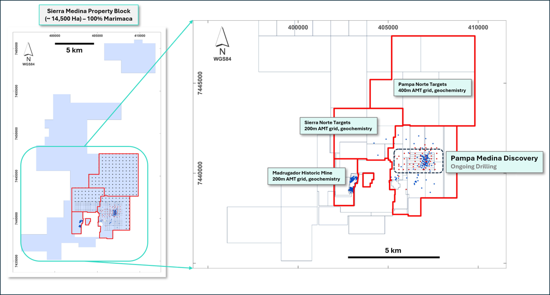
Figure 2: Pampa Medina within Broader 100%-owned Sierra de Medina Property Block
Figure 3: Current Drilling Results and Drilling to Date within Pampa Medina Area of Interest (AOI)
Figure 4: Downhole Lithology and Mineralized Intersection - SPRD-15 from 602m Downhole
Figure 5: Cross Section Looking North - Pampa Medina 7,440,950 N
Figure 6: Cross Section Looking North - Pampa Medina 7,440,800 N
Figure 7: Cross Section Looking North - Pampa Medina 7,440,650 N
Figure 8: Cross Section Looking North - Pampa Medina 7,440,350 N
Hole
Total Depth (m)
From (m)
To (m)
Intersection (m)
% CuT
g/t Ag
SPRD-15
918
348
352
4
0.57
Below Detection
466
682
216
0.96
7.2
Including
466
568
102
0.63
2.1
Including
466
490
24
0.76
3.8
And
504
544
40
0.96
2.9
Including
504
524
20
1.25
5.3
Including
506
512
6
2.00
12.0
And
534
544
10
1.09
0.8
And
600
682
82
1.72
16.3
Including
602
664
62
2.20
21.5
Including
606
656
50
2.42
24.0
Including
606
620
14
3.05
26.7
And
632
644
12
3.25
36.7
SPRD-17
868
386
394
8
0.67
Below Detection
504
628
124
0.57
1.2
Including
522
626
104
0.65
1.4
Including
522
552
30
0.96
1.8
Including
524
544
20
1.28
2.3
And
586
626
40
0.89
2.0
Including
586
600
14
1.36
4.0
734
852
118
0.32
Below Detection
Including
798
852
54
0.45
Below Detection
Including
816
844
28
0.67
Below Detection
Including
828
836
8
0.97
Below Detection
SPRD-12
960
674
698
24
0.45
2.1
Including
674
680
6
0.64
3.3
And
692
698
6
0.98
5.0
748
804
56
0.95
4.2
Including
750
772
22
1.80
9.7
Including
750
758
8
2.42
9.0
And
796
804
8
1.20
2.8
874
892
18
0.41
0.7
SPRD-14
764
204
272
68
0.36
2.3
Including
238
268
30
0.61
4.2
Including
238
246
8
1.10
7.0
And
258
268
10
0.74
7.0
698
714
16
0.66
3.9
Including
704
712
8
1.16
7.8
SPRD-16A
868
184
220
36
0.77
1.1
Including
190
216
26
0.94
1.5
Including
204
216
12
1.58
3.2
SPD-13
590
194
416
222
0.50
Below Detection
Including
246
264
18
1.01
Below Detection
And
322
350
28
1.07
Below Detection
Including
338
350
12
1.90
Below Detection
And
368
416
48
1.05
Below Detection
Including
404
416
12
1.99
Below Detection
SPRD-10
850
538
792
254
0.37
1.6
Including
538
564
26
0.34
0.7
Including
538
546
8
0.60
2.3
And
594
642
48
0.71
3.8
Including
594
622
28
0.88
5.4
Including
594
610
16
1.37
8.5
And
704
792
88
0.46
2.3
Including
704
742
38
0.63
3.4
Including
704
718
14
0.96
7.3
SPRD-11
836
482
562
80
0.35
1.2
Including
526
562
36
0.58
2.7
Including
526
534
8
0.78
2.0
And
552
562
10
1.02
5.0
SMRD-35
640
88
114
26
0.45
2.9
Including
92
110
18
0.59
4.2
Including
102
108
6
1.20
11.3
302
334
32
0.74
4.6
Including
302
320
18
0.96
5.3
SMRD-04
1,028
628
634
6
0.84
3.7
670
872
202
0.27
Below Detection
Including
708
714
6
0.70
Below Detection
And
746
768
22
0.51
2.0
Including
760
768
8
0.79
5.5
And
786
846
60
0.44
1.6
Including
812
842
30
0.61
2.7
Including
814
824
10
0.90
3.6
SMRD-05
1,000
906
934
28
0.32
1.5
974
982
8
0.33
Below Detection
SWR-10
702
632
640
8
0.31
2.8
SWR-11
582
No significant intercepts
SWR-12A
654
578
610
32
0.39
3.3
Including
578
586
8
1.17
11.8
SWR-13
588
422
446
24
0.33
Below Detection
Including
428
436
8
0.64
Below Detection
580
588
8
1.47
7.5
SMR-36
542
No significant intercepts
Table 1: Table of Intersections. All intervals are reported as downhole lengths. True widths are estimated at approximately 80% of reported intervals.
Hole
Easting
Northing
Elevation
Azimuth
Inclination
Depth
SMRD-04
406763.42
7441275.72
1276.67
270
-60
1028
SMRD-05
407361.55
7441273.84
1268.8
270
-60
1000.2
SMRD-35
406699.8
7440201.14
1274.35
270
-60
640
SMR-36
407705.79
7441695.73
1270.61
270
-55
542
SPD-13
407002.02
7440348.7
1269.67
270
-60
590
SPRD-10
406399.78
7440354.96
1281.35
270
-60
850
SPRD-11
406196.52
7440352.91
1285.8
270
-60
836
SPRD-12
406201.16
7440651.24
1288
270
-60
960
SPRD-14
406647.32
7441100.01
1279.04
270
-60
764.1
SPRD-15
406647.82
7440949.96
1278.28
270
-60
918
SPRD-16A
406950.14
7440949.94
1271.77
270
-60
868
SPRD-17
406646.99
7440799.97
1277.86
270
-60
868
SWR-10
406198.13
7441400.02
1294.86
270
-55
702
SWR-11
405902.29
7441399.97
1304.66
270
-55
582
SWR-12A
405606.5
7441399.9
1313.96
270
-55
654
SWR-13
405608.15
7441100.02
1307.07
270
-55
588
Table 2: Drill Collars
Sampling and Assay Protocols
True widths are estimated as 80% of reported intervals, based on down-hole bedding and structural measurements. Diamond drill holes were sampled on a 2m continuous basis, halved by a conventional core splitter on site with one half sent to the Andes Analytical Assay preparation laboratory in Copiapó and the pulps then sent to the same company laboratory in Santiago for assaying. Samples were prepared using the following standard protocol: drying; crushing all samples to -1/4" and passing through a secondary crusher to better than 80% passing -10#; homogenizing; splitting; pulverizing a 400-600g subsample to 95% passing -150#; and a 125g split of this sent for assaying. All samples were assayed for sequential copper %CuT (total copper); %CuS (acid soluble copper), %CuCN (cyanide soluble copper) and CuRes (residual copper). In addition to copper analyses, multi-element analysis including silver (Ag) was undertaken using ICP (multi-element Optical Inductively Coupled Plasma). A full QA/QC program, involving insertion of appropriate blanks, standards and duplicates was employed with acceptable results. Pulps and sample rejects are stored by Marimaca Copper for future reference.
Qualified Person / Competent Person
The technical information in this news release, including the information that relates to geology, drilling and mineralization was prepared under the supervision of, or has been reviewed by Sergio Rivera, Vice President of Exploration, Marimaca Copper Corp, a geologist with more than 40 years of experience and a member of the Colegio de Geólogos de Chile and of the Institute of Mining Engineers of Chile, and who is the Qualified Person for the purposes of NI 43-101 responsible for the design and execution of the drilling program.
The information in this announcement which relates to exploration results for the Pampa Medina Project is based on, and fairly reflects, information and supporting documentation prepared by Sergio Rivera, VP Exploration of Marimaca, a Competent Person who is a member of the Comision Minera (Chilean Mining Commission), Colegio de Geólogos de Chile and of the Institute of Mining Engineers of Chile. Mr. Rivera has sufficient experience that is relevant to the style of mineralisation and types of deposit under consideration and to the activity being undertaken to qualify as a Competent Person as defined in the 2012 Edition of the Joint Ore Reserves Committee Australasian Code for Reporting of Exploration Results, Mineral Resources and Ore Reserves. Mr. Rivera consents to the inclusion in this announcement of the matters based on his information in the form and context in which it appears.
Contact Information
For further information please visit www.marimaca.com or contact:
This news release includes certain "forward-looking statements" under (without limitation) applicable Canadian securities legislation, including, without limitation, statements regarding the development of activities at Pampa Medina, the potential growth of Pampa Medina, and the discovery's potential to complement the MOD. There can be no assurance that such statements will prove to be accurate, and actual results and future events could differ materially from those anticipated in such statements. Forward-looking statements reflect the beliefs, opinions and projections on the date the statements are made and are based upon a number of assumptions and estimates that, while considered reasonable by Marimaca Copper, are inherently subject to significant business, economic, competitive, political and social uncertainties and contingencies. Many factors, both known and unknown, could cause actual results, performance or achievements to be materially different from the results, performance or achievements that are or may be expressed or implied by such forward-looking statements and the parties have made assumptions and estimates based on or related to many of these factors. Such factors include, without limitation: risks that the development activities at Pampa Medina will not progress as anticipated, or at all, risks related to share price and market conditions, the inherent risks involved in the mining, exploration and development of mineral properties, the uncertainties involved in interpreting drilling results and other geological data, fluctuating metal prices, the possibility of project delays or cost overruns or unanticipated excessive operating costs and expenses, uncertainties related to the necessity of financing, uncertainties relating to regulatory procedure and timing for permitting submissions and reviews, the availability of and costs of financing needed in the future as well as those factors disclosed in the annual information form of the Company dated March 27, 2025 and other filings made by the Company with the Canadian securities regulatory authorities (which may be viewed at www.sedar.com). Readers should not place undue reliance on forward-looking statements. Marimaca Copper undertakes no obligation to update publicly or otherwise revise any forward-looking statements contained herein whether as a result of new information or future events or otherwise, except as may be required by law.
None of the TSX, ASX or the Canadian Investment Regulatory Organization accepts responsibility for the adequacy or accuracy of this release.
This announcement was authorised for release to the ASX by the Board of Directors of the Company.
Nature and quality of sampling (eg cut channels, random chips, or specific specialised industry standard measurement tools appropriate to the minerals under investigation, such as down hole gamma sondes, or handheld XRF instruments, etc). These examples should not be taken as limiting the broad meaning of sampling.
Include reference to measures taken to ensure sample representivity and the appropriate calibration of any measurement tools or systems used.
Aspects of the determination of mineralisation that are Material to the Public Report.
In cases where ‘industry standard' work has been done this would be relatively simple (eg ‘reverse circulation drilling was used to obtain 1 m samples from which 3 kg was pulverised to produce a 30 g charge for fire assay'). In other cases more explanation may be required, such as where there is coarse gold that has inherent sampling problems. Unusual commodities or mineralisation types (eg submarine nodules) may warrant disclosure of detailed information.
All current drilling conducted at Sierra Medina, which includes the Pampa Medina deposit, was completed under the supervision of a registered professional geologist as a Competent Person/Qualified Person (QP) who is responsible and accountable for the planning, execution, and supervision of all exploration activity as well as the implementation of quality assurance programs and reporting.
Drilling reported is Reverse Circulation "RC" collared and Diamond ("DDH") tailed drilling
Assay samples were prepared at a laboratory site in Copiapó and assayed by Andes Analytical Assay Ltd. (AAA) in Santiago.
Sierra Medina´s diamond drill holes are drilled and sampled on a continuous 2-meter basis, halved by a conventional core splitter on site, with one half sent to the Andes Analytical Assay preparation laboratory in Copiapó and the pulps then sent to the same company laboratory in Santiago for assaying.
Sierra Medina RC holes are drilled and sampled on a continuous 2-meter basis and riffle split on site up to one-eighth (12.5%) of its volume, after which samples are sent for preparation and assaying.
Marimaca staff supervised all the drilling and sampling.
DD recoveries were controlled by accurate core recovery measurement control was extended toward the division process realized in the drill location.
DD recoveries were measured by core length measurement and compared with the effective core run. Marimaca technical staff checked all data.
Measured recoveries are over 95% for DDH drilling, without significant variations and unrelated to copper grades.
RC recoveries were controlled by weighing samples and accurate control was extended toward the division process realized in the drill location.
RC recoveries were measured in weight percent as compared with a theoretical sample weight. Marimaca technical staff checked all data.
Measured recoveries are over 95% for RC drilling, without significant variations and unrelated to copper grades.
Drilling techniques
Drill type (eg core, reverse circulation, open-hole hammer, rotary air blast, auger, Bangka, sonic, etc) and details (eg core diameter, triple or standard tube, depth of diamond tails, face-sampling bit or other type, whether core is oriented and if so, by what method, etc).
Drilling reported RC collared and DDH-tailed drilling, DDH drilling commenced when the contact between the upper volcanics and upper sediments is encountered, which is variable in depth
DDH drilling is drilled in HQ and NQ standard core diameters
Drill sample recovery
Method of recording and assessing core and chip sample recoveries and results assessed.
Measures taken to maximise sample recovery and ensure representative nature of the samples.
Whether a relationship exists between sample recovery and grade and whether sample bias may have occurred due to preferential loss/gain of fine/coarse material.
Sierra Medina´s DDH holes are drilled and sampled on a continuous 2-meter basis, halved by a conventional core splitter on site, with one half sent to the Andes Analytical Assay preparation laboratory in Copiapó and the pulps then sent to the same company laboratory in Santiago for assaying.
Sierra Medina RC holes are drilled and sampled on a continuous 2-meter basis and riffle split on site up to one-eighth (12.5%) of its volume, after which samples are sent for preparation and assaying.
Marimaca staff supervised all the drilling and sampling.
DD recoveries were controlled by accurate core recovery measurement control was extended toward the division process realized in the drill location.
DD recoveries were measured by core length measurement and compared with the effective core run. Marimaca technical staff checked all data.
RC recoveries were controlled by weighing samples and accurate control was extended toward the division process realized in the drill location.
RC recoveries were measured in weight percent as compared with a theoretical sample weight. Marimaca technical staff checked all data.
Measured recoveries are over 95% for RC drilling, without significant variations and unrelated to copper grades.
Logging
Whether core and chip samples have been geologically and geotechnically logged to a level of detail to support appropriate Mineral Resource estimation, mining studies and metallurgical studies.
Whether logging is qualitative or quantitative in nature. Core (or costean, channel, etc) photography.
The total length and percentage of the relevant intersections logged.
All holes were geologically logged on digital data capture.
The data collected are rock, structure, alteration and mineralization based on drilling intervals, recoveries and analytical results.
After validation, the mineral and alteration zones were defined.
The results were entered in the database as a table with all mapped data and a consolidated log of the drill was prepared.
Most of this work was done by experienced senior consultant geologist supported by consultant junior geologist.
In addition to measuring deviations, most of the holes were surveyed using an optical tele viewer (OPTV or BHTV), with structures and orientation measurements, which continuously and thoroughly recorded the holes' walls and measured structures.
The structures were measured in ranks according to their width and the results were reported and plotted on stereographic networks and rosette diagrams.
Sub-sampling techniques and sample preparation
If core, whether cut or sawn and whether quarter, half or all core taken.
If non-core, whether riffled, tube sampled, rotary split, etc and whether sampled wet or dry.
For all sample types, the nature, quality and appropriateness of the sample preparation technique.
Quality control procedures adopted for all sub-sampling stages to maximise representivity of samples.
Measures taken to ensure that the sampling is representative of the in situ material collected, including for instance results for field duplicate/second-half sampling.
Whether sample sizes are appropriate to the grain size of the material being sampled.
Sierra Medina´s DDH holes are drilled and sampled on a continuous 2-meter basis, halved by a conventional core splitter on site, with one half sent to the Andes Analytical Assay preparation laboratory in Copiapó and the pulps then sent to the same company laboratory in Santiago for assaying
The last split yields "sample A", which is sent for preparation and assaying, and "sample B", which is used to obtain drill cuttings (1 kg) and coarse/preparation duplicates and then stored in special facilities on site.
DDH samples are obtained every 2 meters from a half-core, with the other half stored on site.
RC holes are drilled and sampled on a continuous 2-meter basis and its samples riffle split on site three times, up to one eighth (12.5%) of its volume.
The last split yields "sample A", which is sent for preparation and assaying, and "sample B", which is used to obtain drill cuttings (1 kg) and coarse/preparation duplicates, and then stored in special facilities on site.
Samples are transferred by laboratory personnel from the project to Copiapó, and then the preparation pulps are returned to generate the analysis batches. Upon receipt, sample details are logged and insertion points for quality control samples in the sample flow are determined.
Samples were prepared using the following standard protocol: drying; crushing all samples to -1/4" and passing through a secondary crusher to better than 80% passing -10#; homogenizing; splitting; pulverizing a 400-600g subsample to 95% passing -150#; and a 125g split of this sent for assaying. All samples were assayed for sequential copper %CuT (total copper); %CuS (acid soluble copper), %CuCN (cyanide soluble copper) and CuRes (residual copper), and multi-element Optical Inductively Coupled Plasma (ICP). A full QA/QC program, involving insertion of appropriate blanks, standards and duplicates was employed with acceptable results. Pulps and sample rejects are stored by Marimaca Copper for future reference.
Laboratory results are loaded directly from digital assay certificates into the database, in order to minimize error sources.
Quality of assay data and laboratory tests
The nature, quality and appropriateness of the assaying and laboratory procedures used and whether the technique is considered partial or total.
For geophysical tools, spectrometers, handheld XRF instruments, etc, the parameters used in determining the analysis including instrument make and model, reading times, calibrations factors applied and their derivation, etc.
Nature of quality control procedures adopted (eg standards, blanks, duplicates, external laboratory checks) and whether acceptable levels of accuracy (ie lack of bias) and precision have been established.
Samples are prepared at a laboratory site in Copiapó and assayed by Andes Analytical Assay Ltd. (AAA) in Santiago.
Samples were prepared using the following standard protocol: drying; crushing all samples to -1/4" and passing through a secondary crusher to better than 80% passing -10#; homogenizing; splitting; pulverizing a 400-600g subsample to 95% passing -150#; and a 125g split of this sent for assaying. All samples were assayed for %CuT (total copper); %CuS (acid soluble copper). A full QA/QC program, involving insertion of appropriate blanks, standards and duplicates was employed with acceptable results. Pulps and sample rejects are stored by Marimaca Copper for future. In addition to copper analyses, multi-element analysis including silver (Ag) was undertaken using ICP.
All samples were assayed for sequential copper %CuT (total copper); %CuS (acid soluble copper), %CuCN (cyanide soluble copper) and CuRes (residual copper). Silver and an additional 33 elements were analysed using a 0.5g pulp sample and measured by optical ICP.
Laboratory results are loaded directly from digital assay certificates into the database, in order to minimize error sources.
The analytical quality control programs implemented at Marimaca involve the use of coarse/preparation and pulp duplicates for precision analyses and standard reference materials (SRM). QA/QC procedures apply equally to silver and the multi-element suite.
Marimaca has protocols in place for handling analytical results that exceed acceptable limits, which can ultimately trigger re-assays of entire or portions of sample batches.
Verification of sampling and assaying
The verification of significant intersections by either independent or alternative company personnel.
The use of twinned holes.
Documentation of primary data, data entry procedures, data verification, data storage (physical and electronic) protocols.
Discuss any adjustment to assay data.
There are no twinned holes in the dataset
All logging data was completed, and logging data was entered directly into the deposit database.
Laboratory results are loaded directly from digital assay certificates into the database to minimize error sources.
Location of data points
Accuracy and quality of surveys used to locate drill holes (collar and down-hole surveys), trenches, mine workings and other locations used in Mineral Resource estimation.
Specification of the grid system used.
Quality and adequacy of topographic control.
Local contractors carried out the supervision of the drilling operation.
An experienced topographer surveyed the collars.
WGS84 UTM coordinates are used.
Data Well Services carried out the downhole surveys for drill holes.
Data collected is considered adequate for eventual use in mineral resource estimation.
Data spacing and distribution
Data spacing for reporting of Exploration Results.
Whether the data spacing and distribution is sufficient to establish the degree of geological and grade continuity appropriate for the Mineral Resource and Ore Reserve estimation procedure(s) and classifications applied.
Whether sample compositing has been applied.
Due to the nature of mineralisation and the type of exploration discovery drilling program the hole spacing is highly variable.
Data spacing is not considered sufficient to establish geological and grade continuities for Mineral Resource Estimation at the Inferred and Indicated category.
No sample compositing was applied.
Orientation of data in relation to geological structure
Whether the orientation of sampling achieves unbiased sampling of possible structures and the extent to which this is known, considering the deposit type.
If the relationship between the drilling orientation and the orientation of key mineralised structures is considered to have introduced a sampling bias, this should be assessed and reported if material.
Drill hole orientation was generally oriented to be sub perpendicular to the mineralisation but variable in places given the nature of the exploration program being conducted
Assays are reported on a downhole basis
True widths are estimated as 80% of reported downhole intersection widths
Sample security
The measures taken to ensure sample security.
All drilling assay samples are collected by company personnel or under the direct supervision of company personnel.
Samples from Marimaca were initially processed at the project site and shipped directly from the property to a laboratory facility for final preparation, and later, upon their return, to the laboratory for analysis.
Appropriately qualified staff at the laboratories collect assay samples.
Security protocols implemented maintain the chain of custody of samples to prevent unnoticed contamination or mixing of samples and to make active tampering as difficult as possible.
Audits or reviews
The results of any audits or reviews of sampling techniques and data.
It is the Competent Person's opinion that these processes met acceptable industry standards, and that the information can be reported under both JORC and NI43-101 standards and, in the future, be used for geological and resource modelling.
Section 2: Reporting of Exploration Results
Criteria
JORC Code explanation
Commentary
Mineral tenement and land tenure status
Type, reference name/number, location and ownership including agreements or material issues with third parties such as joint ventures, partnerships, overriding royalties, native title interests, historical sites, wilderness or national park and environmental settings.
The security of the tenure held at the time of reporting along with any known impediments to obtaining a licence to operate in the area.
Marimaca Copper Corp. owns a tenement package consisting of approximately 14,500 hectares at the broader Sierra de Medina project area. The concessions are a mix of mining concessions and exploration concessions.
The Sierra de Medina land package comprises 55 concessions owned by ICAL, a subsidiary of Marimaca Copper Corp.
The Pampa Medina Project comprises 12 concessions owned by SCM Elenita over which the Company entered into an option agreement to acquire.
The Madrugador Project comprises 10 concessions owned by SLM Juanita and SLM Madrugador over which the Company entered into an option agreement to acquire.
There are no known impediments to operating exploration drilling campaigns on the project areas.
Exploration done by other parties
Acknowledgment and appraisal of exploration by other parties.
Pampa Medina Concessions
Between 1993 and 1996, Compañía Minera Doña Isabel and Rayrock Ltda carried out an extensive exploration program. The program included a geochemistry program with short Track Drill wells spaced every 50 m along several E-W lines between 2 km and 5 km in length, which extend throughout the district, covering the southeastern part of the Pampa concessions in an area of approximately 460 ha. The aim was to evaluate the rock below the caliche layer. In this area, approximately 600 samples were obtained, representing 40% of the total samples extracted throughout the district, of which 2% of the total have copper anomalies.
For 2003 and 2004, the right to exploit the Pampa 81 (1/20 and 21/40) and Pampa 47 (1/20 and 21/40) concessions by Minera Rayrock Ltda was established.
In 2008, Rayrock Ltda carried out two RC drilling campaigns. The first involved 15,729 m distributed in 38 holes with an approximate mesh of 500 m × 500 m and the second campaign involved 14,913 m in 35 holes with a mesh of 125 m ×125 m in an area of 1,000 × 350 m, recognising mainly copper oxides, with some mixed intervals and small amounts of primary mineralisation.
An exploration campaign was subsequently carried out in 2013, consisting of 45 diamond holes for a total of 18,707 m drilled.
During 2014, Rayrock Ltda continued with the latest exploration campaign, with the completion of 17 diamond drill holes for a total of 5,264 m drilled.
Madrugador Concessions
The Madrugador concessions were previously the subject of limited exploration efforts since the 1980s. Most of the exploration on the Madrugador concessions was conducted by Rayrock from 1993 to 1996 and consisted of diamond and reverse circulation drilling. A total of 23,502 m of diamond and RC drilling in 223 holes had been completed on the property prior to 2005. Proyecta, a Chilean engineering company, conducted a short track RC drilling program on the Madrugador claim in 2005.
During the period 1994 to 1999, Rayrock conducted geological mapping of the property, a stream sediment and soil/road‐cut sampling survey, as well as limited diamond drilling.
In 2007 and 2008, Apoquindo Minerals Inc. (Apoquindo) completed 21,177 m of RC drilling in 132 holes and 1,206 m of diamond drilling in eight holes.
In April 2009, Apoquindo entered into a JV agreement with Minera S.A.
Geology
Deposit type, geological setting and style of mineralisation.
The Pampa Medina district is characterized by Jurassic-Triassic volcanic- and sediment-hosted manto-style copper mineralization. Volcanic-hosted mineralization, such as the shallow Madrugador mineralization, resembles typical Coastal Belt copper-style mineralization. Sediment-hosted mineralization is exposed in old mine workings along the Sierra de Valenzuela District and has also been intersected in deeper drilling beneath areas where the host sediments are covered by volcanics.
The main structural controls are block faulting and a complex of dyke swarms. Copper mineralization observed in drill holes comprises both oxides and sulphides. The predominant oxides are atacamite, azurite and chrysocolla. The oxide zone varies from less than 10m to more than 200m in thickness and is associated with an irregular mixed zone characterized by green copper oxides, mainly atacamite, and copper sulphides, mainly chalcocite, with lesser chalcopyrite and pyrite. At depths of more than 300m, primary mineralization is dominant and consists of chalcopyrite, bornite, variable covellite and pyrite.
Rock alteration is mostly albitization of sediments and little clay is observed in the upper oxidized zones.
Drill hole Information
A summary of all information material to the understanding of the exploration results including a tabulation of the following information for all Material drill holes:
easting and northing of the drill hole collar
elevation or RL (Reduced Level - elevation above sea level in metres) of the drill hole collar
dip and azimuth of the hole
down hole length and interception depth
hole length.
If the exclusion of this information is justified on the basis that the information is not Material and this exclusion does not detract from the understanding of the report, the Competent Person should clearly explain why this is the case.
Drill hole attribute information is included in a table herein.
Data aggregation methods
In reporting Exploration Results, weighting averaging techniques, maximum and/or minimum grade truncations (eg cutting of high grades) and cut-off grades are usually Material and should be stated.
Where aggregate intercepts incorporate short lengths of high grade results and longer lengths of low grade results, the procedure used for such aggregation should be stated and some typical examples of such aggregations should be shown in detail.
The assumptions used for any reporting of metal equivalent values should be clearly stated.
Length weighted averages were used to calculate grade over width.
No specific grade cap or cut-off was used during grade width calculations. The total copper (CuT) weighted average grade of the entire interval is calculated for all intervals over 2m samples lengths. Manto-type deposits can be variable in nature resulting in some intervals having a small number of poorly mineralized samples (<0.1% CuT) included in the calculation.
Silver assays reporting less than 3 gpt Ag detection limit in the ICP analysis were assigned a value of zero.
No metal equivalents have been reported.
Relationship between mineralisation widths and intercept lengths
These relationships are particularly important in the reporting of Exploration Results.
If the geometry of the mineralisation with respect to the drill hole angle is known, its nature should be reported.
If it is not known and only the down hole lengths are reported, there should be a clear statement to this effect (eg ‘down hole length, true width not known').
True widths are estimated at 80% of the reported downhole intersection, however drilling generally targets sub-perpendicular intersections of the mineralized manto units as understood/interpreted at the time of drilling
All intersections are reported on a downhole basis.
Diagrams
Appropriate maps and sections (with scales) and tabulations of intercepts should be included for any significant discovery being reported These should include but not be limited to a plan view of drill hole collar locations and appropriate sectional views.
Please refer to the figures contained herein
Balanced reporting
Where comprehensive reporting of all Exploration Results is not practicable, representative reporting of both low and high grades and/or widths should be practiced to avoid misleading reporting of Exploration Results.
All significant results have been reported
Please refer to the tables herein
Other substantive exploration data
Other exploration data, if meaningful and material, should be reported including (but not limited to): geological observations; geophysical survey results; geochemical survey results; bulk samples - size and method of treatment; metallurgical test results; bulk density, groundwater, geotechnical and rock characteristics; potential deleterious or contaminating substances.
There is no meaningful and material exploration data to report other than the information disclosed in this release
Further work
The nature and scale of planned further work (eg tests for lateral extensions or depth extensions or large-scale step-out drilling).
Diagrams clearly highlighting the areas of possible extensions, including the main geological interpretations and future drilling areas, provided this information is not commercially sensitive.
Over the course of 2026, the Company intends to complete further exploration work at the project area including:
Geophysical surveys
Reverse circulation and diamond core drilling
Of particular focus will be the potential for extensions from the Pampa Medina Deposit north and west